Local Weather History: The March 15-17, 1919 Tornado Outbreak & Piecing the Tricky Reconstruction Together Here (Intense Non-T'Storm High Wind Event & Flooding Amidst Nearby Severe Weather Outbreak)
The mid-March 1919 big severe weather outbreak & the lack of severe storms here, but the intensity of the damaging non-t'storm gradient wind....
When I began piecing this active weather period together like a puzzle, I had researched & knew we had wind damage around here on March 17, 1919. I also found the severe weather with even some long-track, significant tornadoes March 15 to as far east as Mississippi. The Iowa tornado was also of interest. I found we had heavy rainfall & temperatures in the 60s with dew points to +60. My assumption was that we had severe weather that caused the damage & gusts, but further investigation revealed otherwise.....
It wasn't just one system either, but it was two that brought rainfall & t'storms here. The first one brought strong south-southwest winds +40 mph, but it was the second, rapidly-deepening storm that brought the non-t'storm high wind event to our region.
So........
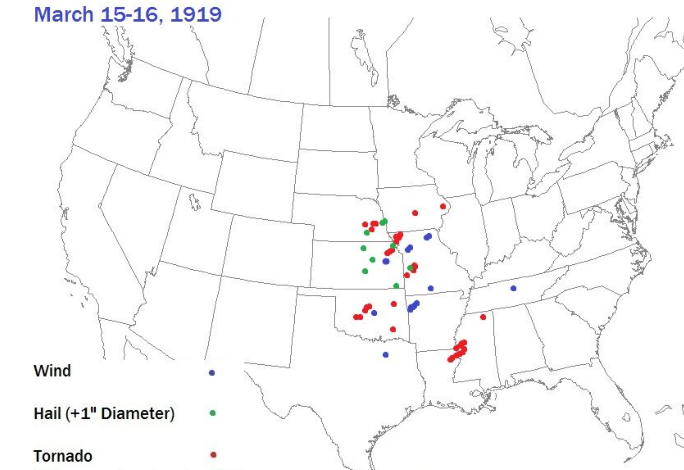
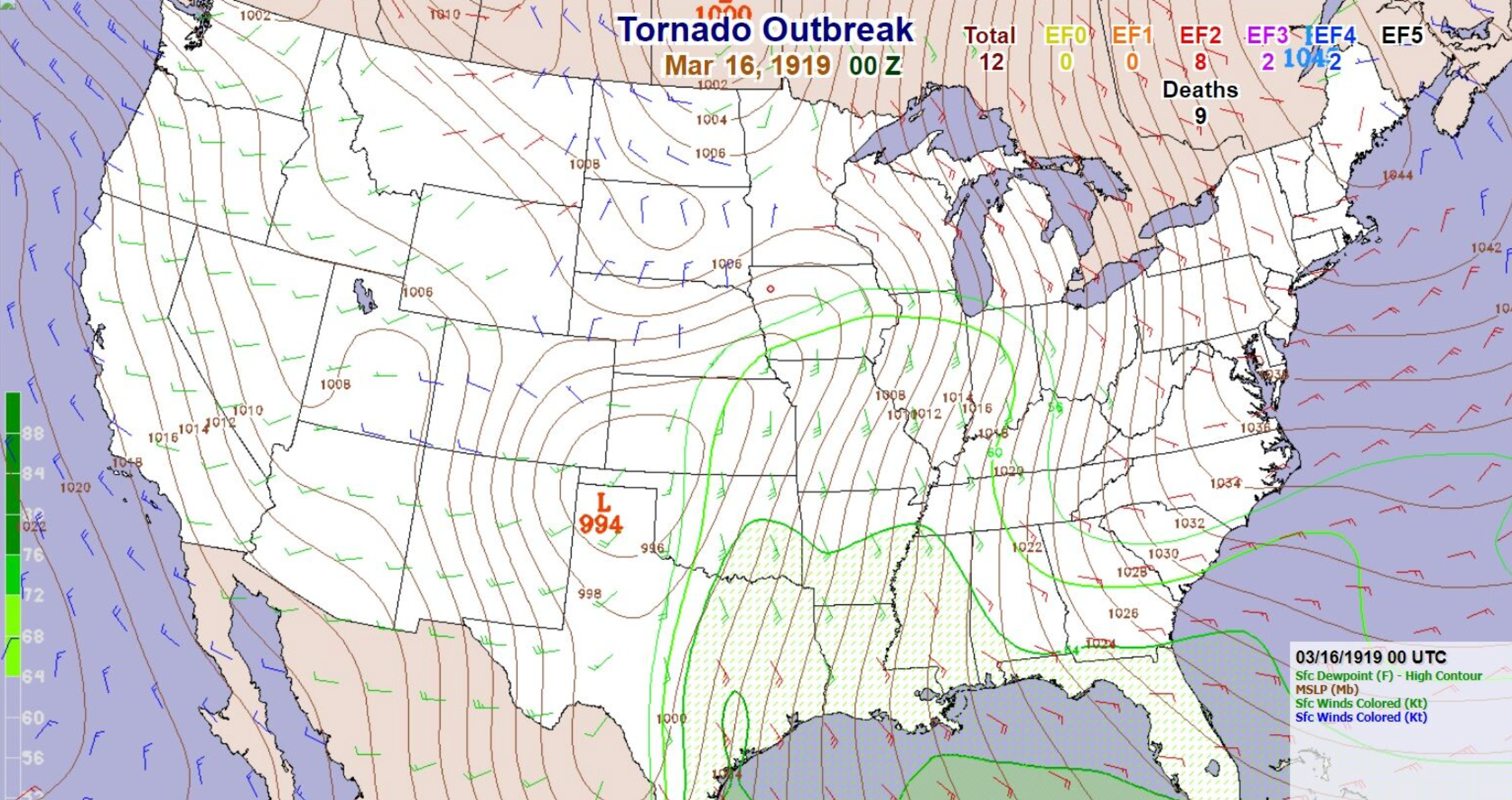
Severe weather outbreak occurred from the Midwest to the South & Southern Plains March 15-16, 1919. Tornadoes were reported as far north as eastern Iowa.
Beginning as a high wind event with very low snow levels, heavy rainfall & even hail-producing t'storms in southern California, it transitioned to an outbreak of at least a dozen tornadoes from Oklahoma, Kansas & Missouri to Arkansas & northeastern Texas to far western Kentucky & Tennessee. This followed a big Deep South outbreak in early March & preceded a violent tornado outbreak Oklahoma & Texas to Arkansas on April 8-9, 1919 that at least 92 people & injured 442.
The severe weather outbreak of mid-March 1919 was impressive with several strong to violent, long-track tornadoes, along with wind & large hail, but it was not severe t'storms that caused our issues here. It was a non-t'storm high wind event on March 17 that was our issue. We dodged the severe storms. The high wind event also occurred with a separate rapidly-deepening surface low.
In our area, many trees & telegraph poles were downed in our area, along with the development of minor structural damage as surface low rapidly deepened atop & just northeast of the viewing area. Winds gusted from the southwest then northwest likely 50-75 mph over the viewing area.
Gusts of 54 mph occurred at Indianapolis, 58 mph Evansville, 68 mph Lexington, Kentucky to at 56 mph Louisville, Kentucky.
Anemometer recorded gusts of 52 mph at Columbus, Ohio, 56 mph Cleveland, Ohio, 52 mph at Erie, Pennsylvania & Hannibal, Missouri 50 mph.
In the severe t'storms, gust of at least 76 mph was recorded at Fort Smith, Arkansas. An 88 mph t’storm wind gust was measured at Wichita, Kansas
In another major storm storm on March 28, a 92 mph non-t'storm wind gust was measured at New York & 56 mph at Norfolk, Virginia to put early Spring 1919’s active weather on full display.
So, here is the storm system & ensuing severe weather from eastern Iowa to Lower Mississippi Valley (below image).
First low that pivoted up to Iowa & brought the severe weather outbreak.
There is the first low that brought the severe weather outbreak from Iowa southwestward.
There is the low once again.
The low & the shear move well away from the area, but note the high dew points & strong low-level flow from the south. Heavy rainfall & t'storms occurred in this time period.
It was this weak low that would bring our big wind event here.
There it is early in the morning of March 17, in the process of rapid deepening with lots of rainfall.
Keep reading with a 7-day free trial
Subscribe to Chad’s Weather Blog to keep reading this post and get 7 days of free access to the full post archives.