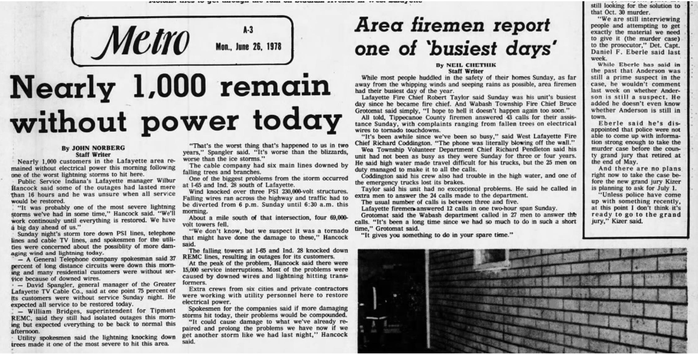
Local Weather History: June 25, 1978's Billion-Dollar Supercell Clusters with Tornadoes, Major Flooding, Damaging Winds, Large Hail....
I spoke with my father-in-law about this on Memorial Day & he remembers this storm well, inspiring me to post about it a month early from the 47th anniversary.....
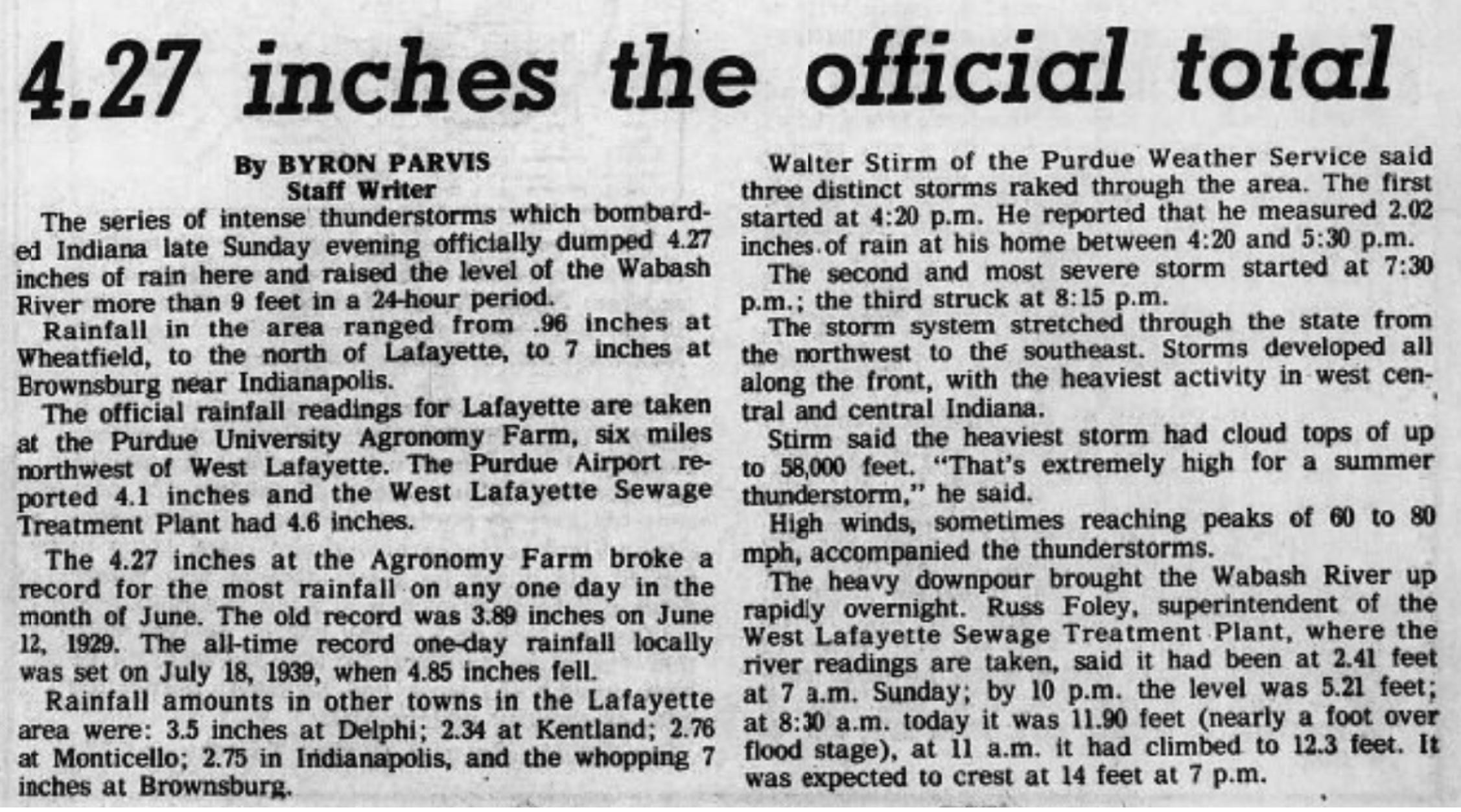
June 24-25, 1978 saw 2-3 main clusters of supercell storms over northern Illinois with one main one tracking along the US 52 corridor over our viewing area. Between these rounds of storms, total damage from flooding, hail, wind & tornadoes amounted to an inflation-adjusted value of near $1 billion. Damage from an EF3 tornado & major flooding in Indianapolis alone was more than $1/2 billion. I take a look back at these supercells & the amount of rainfall & severe weather they produced with also a dig into the tracks of multiple tornadoes.
First, the storms' measured gust at the Purdue Airport is still the third highest since 1944.
Solid, hourly wind data is absent in the Greater Lafayette dataset until 1944 onward. In the 1944-2024 data from the airport, these are the top 5 highest wind gusts measured there:
1. 90 mph.....June 20, 1964
2. 86 mph.....June 10, 1963
3. 80 mph.....June 25, 1978
4. 77 mph.....December 6, 1998
5. 76 mph.....November 26, 1952
That 80 mph was measured at 6 p.m. as the cluster of HP supercells along the warm front that brought brief tornado near Klondike to Tippecanoe & Clinton counties & later Marion County moved in.
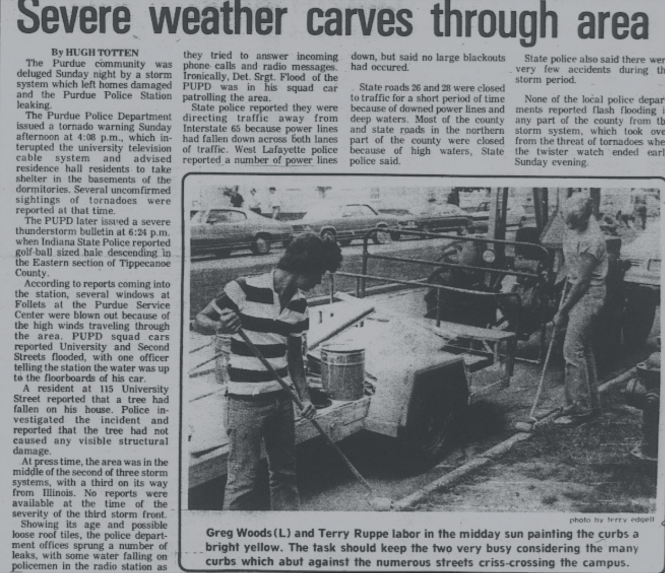
Damage was widespread in West Lafayette & Lafayette from damaging straight-line winds & apparent EF0 tornado damage. This same cluster of supercells had already produced significant damage in Illinois as it developed & moved along the warm front.
Severe storms with the front had been going on since the evening before:
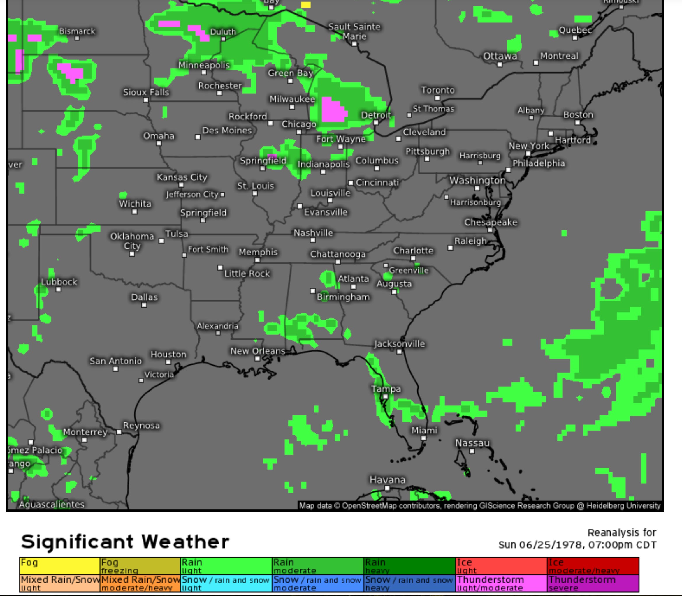
New severe storms occur late morning to early afternoon over northern & eastern Illinois on June 25. New severe storms also occurred over northern Illinois during the night to early morning hours of June 25-26 with flooding rainfall:
A funnel cloud was first reported from developing storm 2 miles southeast of Fowler at 3:53 p.m. A tornado reportedly briefly touched down near Klondike about one hour later, but no structural damage was reported.
This began an HP supercell & then a cluster of HP supercells that according to the NWS report, "damage track was rather continuous into Indianapolis". This could be called the I-65 supercells, as the whole cluster tended to follow the interstate to the southeast......or better yet, the 52 supercells as the first incidence of the severe weather was the funnel observed just southeast of Fowler.
At 6 p.m., severe storm rolled into west side of West Lafayette with 80 mph gust at the Purdue Airport. Extensive tree damage on campus with many large limbs & tree tops broken. 15 large, older trees were completely felled. The windows of University Bookstore were blown out with roof damage to homes & buildings amidst downed power poles & lines. Damage continued into the southside of Lafayette with extensive tree & powerline damage & largely roof damage to homes in businesses. NWS survey from the time has tornado path embedded in 60-80 mph straight line winds beginning in a wooded area southwest of modern-day Woodwind Lane about 1.5 miles west-southwest of Purdue Horticulture Park. Survey indicates, the skipping EF0 moved southeast, averaging only around 100' wide of rotary motion of the trees.
The tornado then skipped up & down apparently over the Purdue Airport with a wind gust of 80 mph recorded. It then tracked over the modern-day area of between River Road & the Wabash River on U.S. 231. Causing mostly tree damage, it crossed over modern-day Armstrong Park, caused some minor roof damage with the straight-line winds around Brady Lane & modern-day South 18th. Beyond that, it was all rural farm fields & modern-day Veteran's Memorial Parkway was a gravel road through massive fields. Tracking through corn & soybean fields, it then crossed US 52 at 550 South, narrowly missing a home.
Golfball-sized hail (1.75" diameter) was reported from Murdock Park eastward along South Street with window damage to homes & businesses (many cars also damaged by the wind-driven hail). Marble or 0.5" hail was reported in the city of West Lafayette.
According to the survey, the actual tornado began to strengthen greatly once it closed in, then paralleled I-65. Extensive, heavy home damage, significant tree damage (large trees twisted off & completely de-limbed) & barn destruction occurred with numerous billboards destroyed & crops leveled in the tornado path. It was in far southeastern Tippecanoe to far southwestern Clinton counties that the tornado reached F3 or modern-day EF3 strength with winds peaking likely at 160 mph.
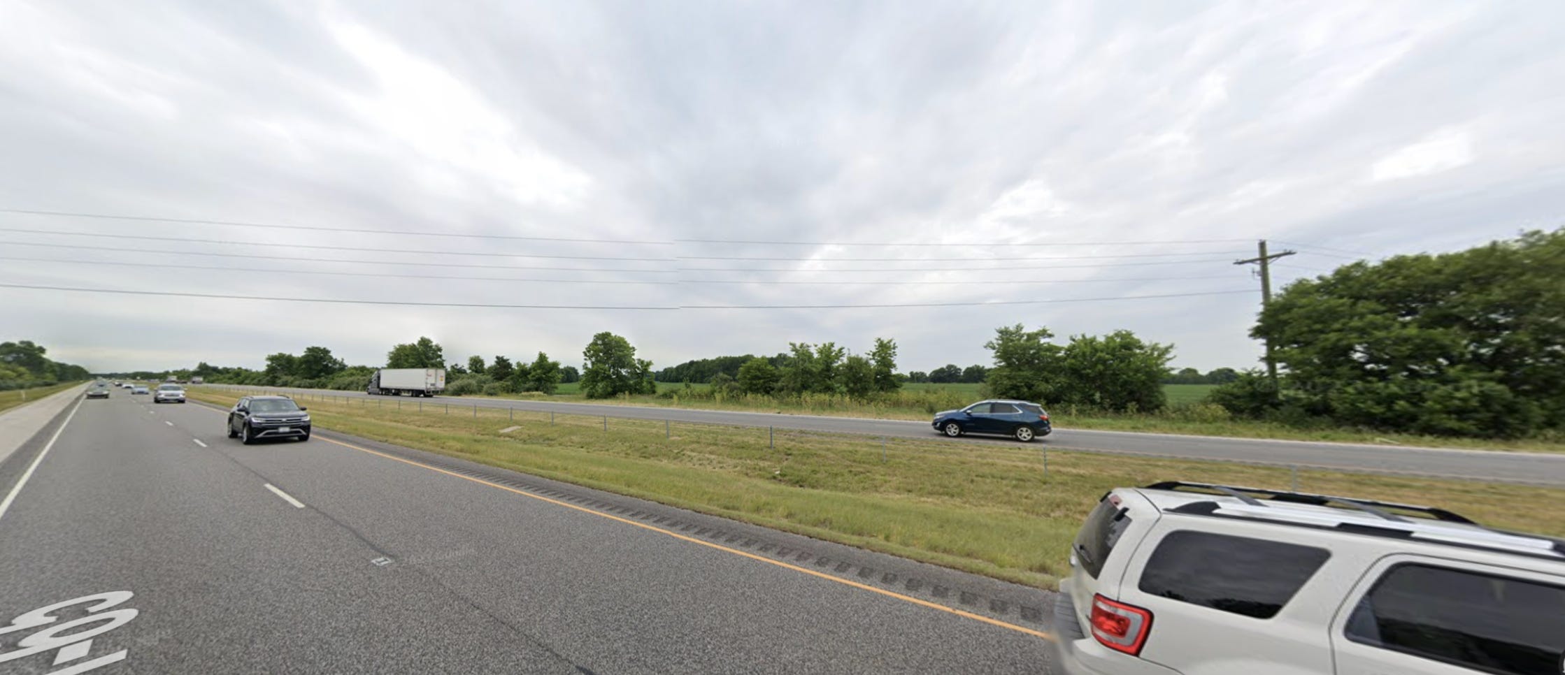
So, much of the path was EF0 to possibly EF1 (EF1 indicated on two industrial buildings on what was then the south-side of Lafayette in 1978). Once it was northwest of Laramie Creek, it strengthened with the EF1-EF2 damage. It crossed I-65 where East County Road 800 South was closed for I-65 construction (modern day Google Streetview below with tornado moving right to left in the image at an angle). It then paralleled 65 with it tracking north of Ken-Do-Lake campground, peaking in strength with complete barn destruction.
The tornado then rapidly weakened & lifted about 0.5 mile northwest of I-65 in a field 1.5 miles northwest of the Highway 28 eastbound exit off I-65.
0.5 mile on the right of this pic on I-65 (northbound) is where this tornado would have lifted.
This is that location looking eastbound:
Damage in the Laramie Creek to northwest of 28 exit corridor (not to crops, but just structures) was +$1/2 million. In the city of Lafayette alone $1/2 million in damage was reported with 100 insurance claims due to damage by homeowners reported. Again, this does not include crop damage or damage to timber. 4-5" of rain fell very quickly from Greater Lafayette to southwestern Clinton County (some of it in only 1.5 hours). This resulted in substantial to significant flash flooding. Two bridges were washed our in rural southeast Tippecanoe to southwest Clinton counties & flooding damage in the entire Greater Lafayette to near 28 corridor amounted to $4.8 million. NWS also stated that several other bridges were also "badly damaged". In addition, damaged winds of 60-80 mph occurred for nearly the entirity of the path as well (1-2 miles wide). The tornado path ended up near 18 miles. No damage was reported between west of Frankfort & Sheridan areas. The next reports of wind damage came from 421 & 32 east of Lebanon from straight-line winds.
The storms arrived in the Zionsville area & northwest side of Indianapolis at 7-7:15 p.m. Windows were blown out at Pike Middle School just east of Zionsville near 71st Street in the Indianapolis metro area at that time. Wind gust exceeded 100 mph at the Indianapolis Power & Light Company station on the northwest side of the city on 91st Street.
A tornado touched down at 6800 Georgetown Road & tracked more than a mile before lifting again with EF0-EF1 strength, embedded in a 2-mile wide swath of intense straight-line winds of 60-100 mph. "Major flooding" (per NWS quote) occurring in central Marion County with wind damage occurring over much of the county (city of Indianapolis).
3-7" rain fell in Indianapolis resulted in nearly $100 million in flood damage alone. Three large bridges collapsed in the city alone, as well.
Heavy wind damage occurred across central Marion County, but it was the EF3 tornado that brought the worst damage. 27 homes were completely destroyed, 300 damaged & 5 apartment complexes were very heavily damaged. 9 business firms received heavy damage & metal high-tension powerline transmission towers were destroyed. Damage was upwards of $1/2 BILLION dollars. 1 person was killed, 25 injured.
Tracking from north of Indianapolis Airport to Beech Grove, the tornado seemed to peak in intensity in the Beech Grove area with it still wrapped in damaging winds. It seemed to exhibit EF0-EF2 strength until it reached southeast Indy with rapid uptick to EF3 strength.
My father-in-law (Rusty Nichols) told me of how their company, Farm Fans Grain Dryers, saw damage to the plant from the tornado & grain dryers were blown & tossed onto I-465. The interstate was closed as a result. The plant was down for a least a week. Large air conditioning roof top units were ripped & tossed off nearby industrial buildings. He explained to me that it was a very memorable, highly-damaging storm that left a big impression on him. One memory of his involves seeing random microwave unit that was still in plastic laying in the middle of County Line Road after the storm that had been picked up & tossed from a nearby factory.
Straight-line winds of 60 to +80 mph then continued into Shelby County, Indiana, but also Hendricks, Monroe & Morgan counties. A gust of 81 mph was measured on the Indiana University campus at Bloomington as the supercell cluster apparently become more linear with time.
The great 1978 HP supercells were indeed billion-dollar disasters for the US 52 corridor.
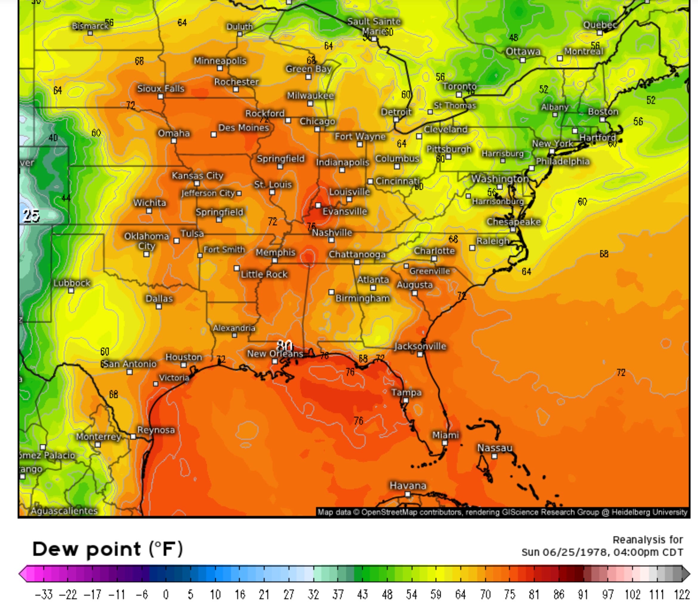
Surge of +1500 J/kg surface CAPE northeastward & strongly sickle-shaped hodographs indicate the unstable, sheared environment for supercells & a few strong tornadoes. With temperatures in the 80s & dew points well into the 70s, there was a lot of CAPE focused near the surface with dew point depressions of around 10 degrees, resulting in lower, tropical cloud bases & easier way to get funnels to form.
These high dew points also resulted in the extremely high rainfall rates.
The +3" rainfall totals from Fowler to Indianapolis along US 52 & I-65:
ECMWF ERA reconstruction shows the supercell clusters moving southeastward:
The warm front shows up well with intensely hot upper ridge in the Plains & us being on the edge of the heat with warm front & "Ring of Fire" set-up here:
The intense, hot upper ridge shows up via the ERA with upper level jet north & northwest of our area.............but note the piece of strong upper jet winds branching off from the main jet from Iowa to north-central Indiana. That was key to also helping produce the supercells.
The dew points were very high at 74-78 here:
Keep reading with a 7-day free trial
Subscribe to Chad’s Weather Blog to keep reading this post and get 7 days of free access to the full post archives.