2. Wind gusts 58 mph or greater along the entire path of the line.
3. Persistent pockets of 75 mph or greater gusts.
4. Long-lived event with lack of weakening along entire path with very fast movement of at least 50 mph along much of the path.
TYPES:
1. Progressive Derecho
a. Occurs on the periphery of hot upper ridge in the "Ring of Fire" usually in the summer.
b. Sparked by shortwave &/or MCV on periphery of upper ridge
c. Often single-bowed with lower width than other derecho types.
d. Typical of explosive environments with deep instability in hotter times of the year.
e. These tend to track in a southeastward direction.
2. Serial Derecho
a. Occurs with larger-scale storm system (surface low, cold front & warm front).
b. Often multiple-bows with this type of derecho.
c. Much larger width compared to Progressive Derecho.
d. More typical of the cool-season in winter, spring or fall, compared to summer.
e. Often lower instability, but high speed & directional shear to compensate.
f. These tend to move east to northeastward.
3. Hybrid Derecho
a. Has features of both Progressive & Serial Derechos
b. Can be with larger-scale storm systems on periphery of intense heat.
c. Can also be a smaller-scale single bow derecho in a large scale storm system.
d. They may vary in movement; east, northeast or southeast.
NUMBER OF DERECHOS PER DECADE (MOST HAVE 2 EACH DECADE):
2020s: 3
2010s: 5
2000s: 3
1990s: 3
1980s: 2
1970s: 2
1960s: 2
1950s: 1
1940s: 1
1930s: 2
1920s: 5
1910s: 2
1900s: 2
1890s:
1880s:
1870s:
1860s: 2
1850s:
The most common derecho to impact the viewing area is the Single Bow Progressive Derecho, which occurs in the "Ring of Fire" pattern on the periphery of an upper ridge, usually with an intense heat wave.
The 1910s & 1990s were unique in that no Progressive Derechos hit the area. They were mostly cool-season Serial Derecho events, while one Hybrid Derecho event occurred.
Most of our derechos tend to occur June-August.
In fact, the most frequent occurrence & peak of derecho season is July 1.
The decade of the 1920s & 2010s saw the greatest number of derechos impacting our area with 5. As of July 16, 2024, our totals for the decade of the 2020s is 3.
Max Gust In Our Viewing Area: M75 mph Purdue Airport
Track Length: Approximately 580 miles
Maximum width: 325 miles
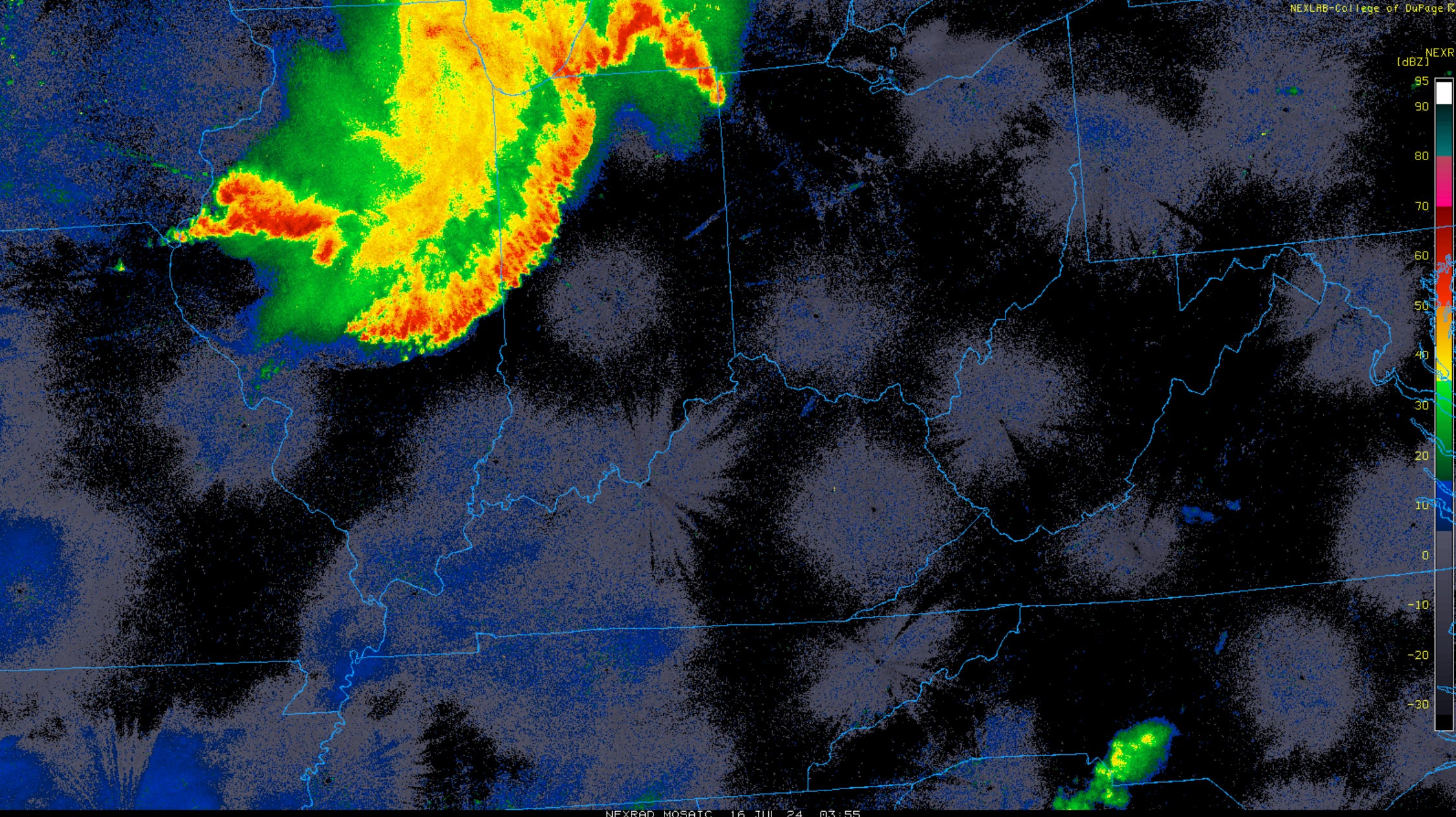
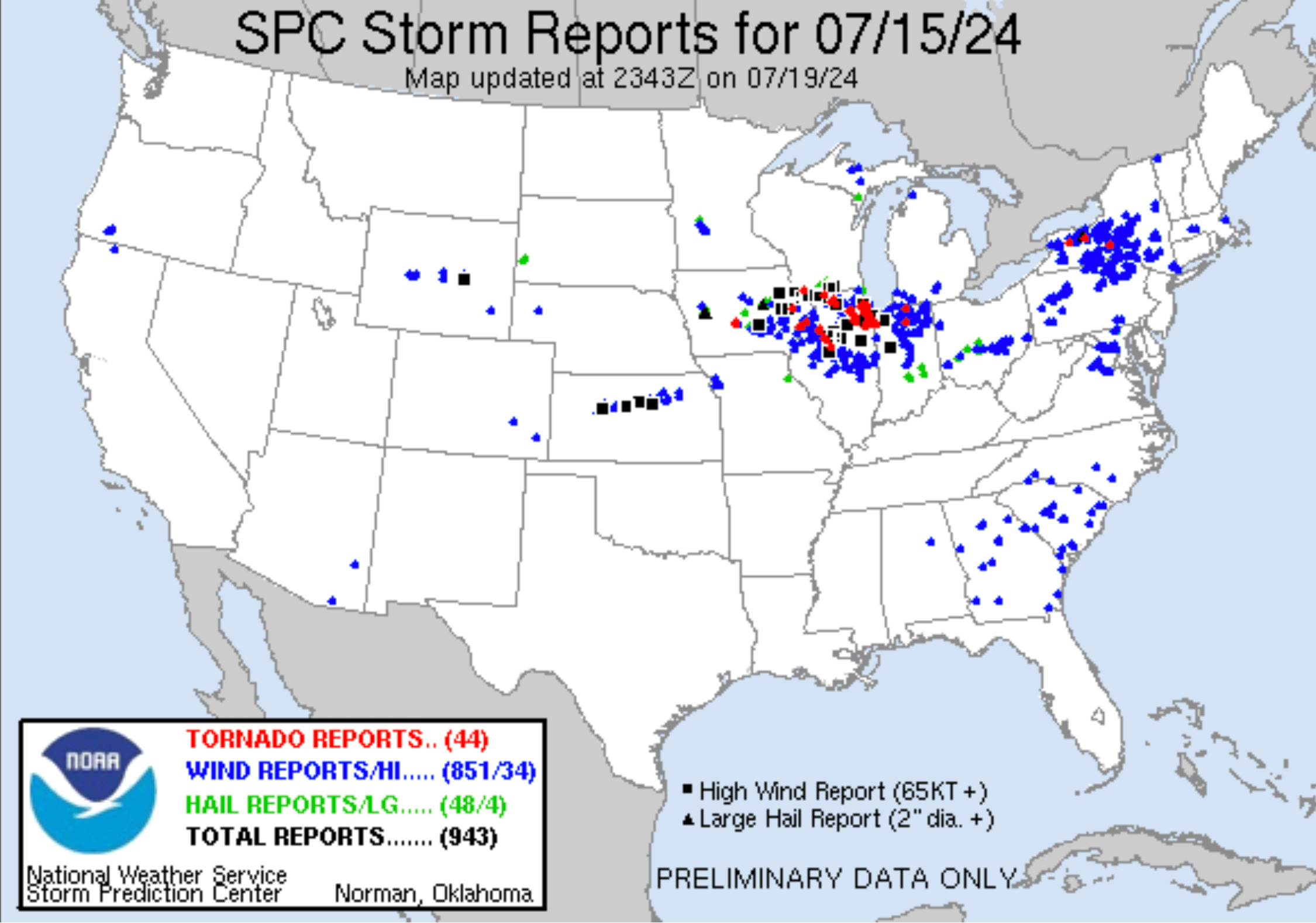
This derecho began as a supercell with damaging wind & tennis ball-sized hail in far western Iowa & evolved into a two, then one bow derecho on the periphery of an intense heat wave with dew points to the 80-84 range & extreme heat indices to +110.
Winds were measured up to 97 mph in eastern Iowa & 105 mph in Illinois with widespread tree, powerline & structural damage amidst the wind & a few embedded brief tornadoes. Per damage seen, +100 mph winds occurred in spots from Iowa all the way to Indiana.
One person was injured near Auburn, Indiana when tree fell on semi, while a person was killed at Cedar Lake, Indiana by falling trees unto a home. Other injuries occurred when cars were tangled in live high-voltage lines on I-55 in Illinois after transmission towers were felled in the derecho. A gust of 93 mph was measured in far northwest, Illinois with multiple gusts 75-84 mph eastern Iowa to southwestern Wisconsin, including A gust of 105 mph in Marshall County, Illinois was followed by gust measured at 101 mph in Ogle County. A gust of 111 mph occurred at Dunlap, Illinois. 80 mph gust was measured near Henry, also in Marshall County, while Chicago's O'Hare Airport gusted to 75 mph. Gusts of 75-95 mph in Woodford County, 71 mph at the Bloomington, Illinois Airport occurred, in addition to 78 mph gust in La Salle County. Structural damage occurred on multiple farms from Iowa to Indiana & extensive structural damage occurred in Channahon, Illinois (Will & Grundy counties). An EF1 tornado went through the heart of Bettendorf, Iowa with winds of 100 mph, while EF0 & EF1 tornadoes occurred in Elkhart & Marshall counties in Indiana to name a few of the numerous brief tornado spin-ups in the derecho (at least 30 EF0-EF1s & one EF2). An EF2 tornado tracked from Lake to Porter counties with an unusually long (for a derecho) 29-mile track. Many powerlines were downed in Indianapolis with a gust of 58 mph measured at the Indianapolis International Airport. Trees were also blown down from northwest Ohio to southern Lower Michigan to as far east as southwest Ontario.
In the viewing area, numerous gusts 60-75 mph (some likely even 80 mph) occurred with trees & limbs reported down in parts of every county in the viewing area with some areas of corn bent or flattened. Power outages were widespread with tens of thousands without power, including +10,000 households just in West Lafayette & Lafayette. Extensive tree damage occurred at Stewart Woods, Celery Bog & other preserves in & around Tippecanoe County. Crews from Ohio & Kentucky were called to Tippecanoe County alone to assist in replacing damaged lines & snapped poles. Wind gusted to 75 mph at the Purdue Airport, 65 mph at the Winamac Airport, 67 mph at the Galveston Airport, 67 mph near Lincoln in Cass County, 71 mph at Athens in Fulton County, 62 mph at the Kentland Airport & 65 mph southwest of Kewanna. Jim in Kentland measured a gust to 73 mph at his Kentland home, while gust of 72 mph was measured 5 ENE Michigantown. 56 mph gust was measured at the Kokomo Airport & 60 mph in downtown Rochester.
As often seen with Progressive Derechos, the back side of the derecho produced training torrential storms in west-central to southern Illinois with up to +8" of rainfall. I-64 was closed between St. Louis & Mt. Vernon, Illinois & evacuation orders made for eminent dam failure in Washington County, Illinois. This rain fell atop rainfall experienced from Beryl remnants.
2. June 28-29, 2023
Single Bow Progressive Derecho
Max Gust In Our Viewing Area: M74 mph Crawfordsville Municipal Airport
Track Length: Approximately 1327 miles
Maximum width: 185 miles
This derecho had origins in southeastern Wyoming & northeastern Colorado to western Nebraska with large hail (up to 4” in diameter), wind (gusts measured to 82 mph) & tornadoes. Gusts of 77-82 mph continued to be clocked from northern Kansas to southern Nebraska with damage as the derecho raced eastward. 45 power poles were snapped alone 3 miles north of Benkelman, Nebraska. Winds of 90-100 mph then began to occur in northern Missouri with significant damage. Winds of 90-120 mph then occurred in northeast Missouri to far northwest Illinois with grain bins downed & tens of thousands of crops flattened. The derecho then raced well into Illinois with continued widespread damage with winds 60-90 mph. A wind gust of 82 mph was measured near Champaign, while the Champaign Willard Airport measured 79 mph gust. Multiple airport hangars were damaged there, while gust of 75 mph was measured at the Decatur, Illinois Airport. 6 EF0-EF2 tornadoes occurred with the event in Illinois, 1 in Missouri & 2 Nebraska/Wyoming.
The line then reached our viewing area with gust of 70 mph clocked at Covington, 74 mph at the Crawfordsville Airport, 64 mph east of Rossville, 54 mph Purdue Airport, 52 mph 3 E Fowler, 61 mph 4 NW Monticello & 70 mph Thorntown. Many trees & powerlines were knocked down with thousands of power outages in Benton, Tippecanoe, Clinton, Warren, Fountain & Montgomery counties.
The derecho continued southeastward with gust to 70 mph at the Indianapolis International Airport & Vincennes to 58 mph Bloomington, Indiana. Numerous trees & limbs were reported down between Martinsville & Bloomington. 70-80 mph winds raked a chunk of west-central Indiana & eastern Illinois with State of Emergency declared in Vigo County, Indiana from storm damage. Many barns were unroofed & grain bins downed with thousands of trees damaged or toppled amidst damage to many buildings. Wind damage continued into Kentucky & Tennessee with gust of 68 mph measured in Graves County, followed by 60 mph gust measured in the Nashville, Tennessee area. Injuries were reported in Rush & Clark counties in Indiana. Wind damage then continues into Alabama with the last reports late on the evening of June 29 southwest of Birmingham of trees downed.
3. August 10, 2020
"Flat Corn" Single Bow Progressive Derecho
Max Gust In Our Viewing Area: M81 mph 5 Miles WNW Kentland
Track length: Approximately 631 miles
Maximum width: Approximately 220 miles
This particular derecho produced measured winds of up to 126 mph in Iowa with damage showing some areas seeing gusts to 140 mph. 100 mph wind gusts occurred in Illinois with 15 confirmed tornadoes. Up to 45% of the corn crop in Iowa was lost as millions of acres were flattened by the wind. Some counties lost 90% of their crop.
Three tornadoes occurred in Indiana, including an EF0 north of Kentland just east-northeast of where a gust of 81 mph was measured (sustained winds at 68 mph). Power outages extended more than a week in Iowa & parts of northwestern Illinois. In our area, widespread 50-70 mph winds (isolated +70 mph) occurred with some degree of wind damage reported in every county of the viewing area with numerous power outages.
2010s:
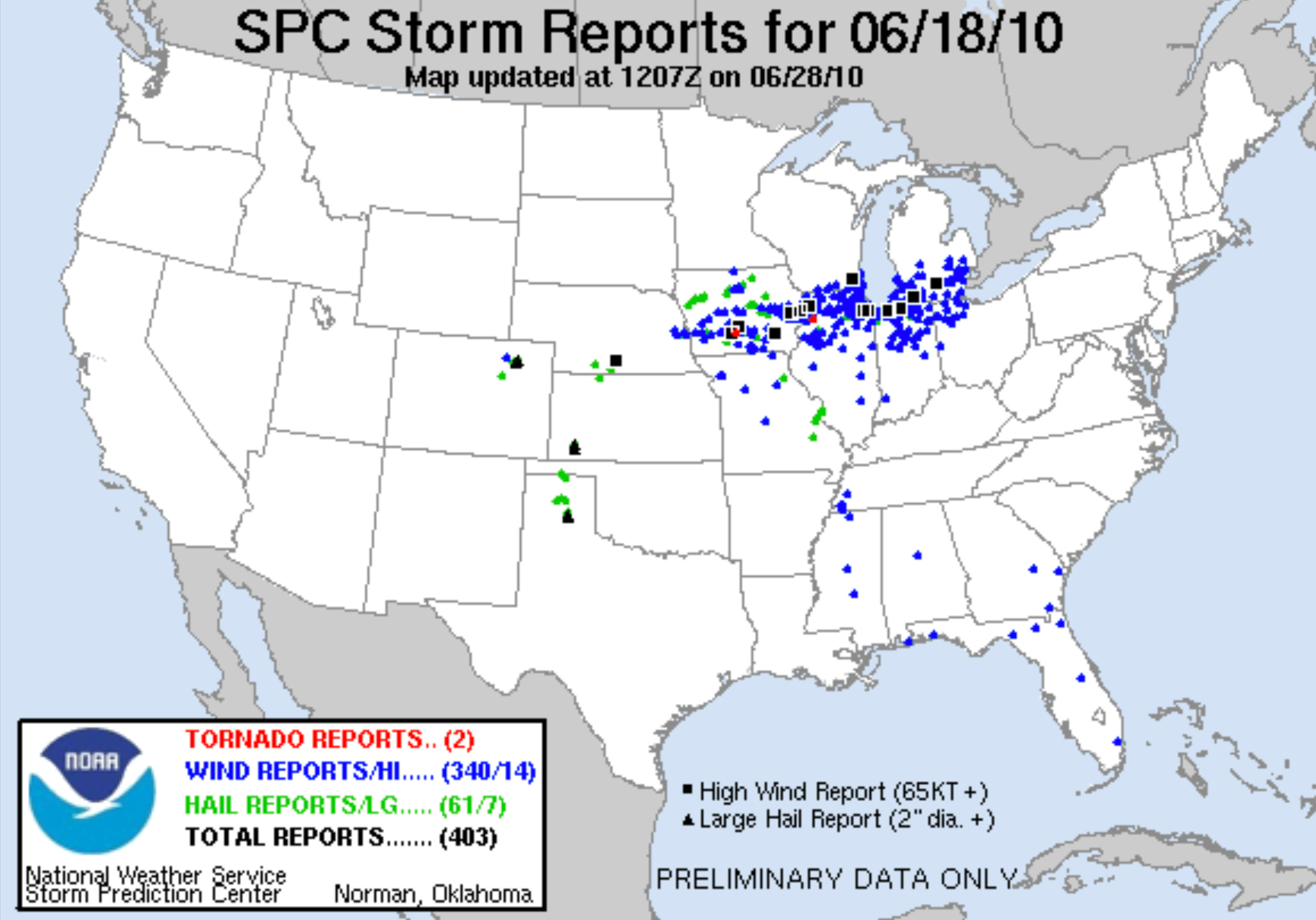
1. June 18, 2010
Single Bow Progressive Derecho
Max Gust In Our Viewing Area: M80 mph 1 SW Battle Ground
Track length: Approximately 665 miles
Maximum width: Approximately 230 miles
Another severe weather outbreak in the very active first half of June 2010, this derecho brought winds of up to 80 mph to the area. Several homes & one church reported roof damage in the area from overall 55-80 mph winds. 70 mph gust northeast of Winamac was accompanied by nickel-sized hail. A gust of 64 mph was measured at WLFI with limbs down, while multiple trees were blown down at nearby Celery Bog & McCormick Woods. Some White Oak trees toppled on the northeast end of McCormick woods were 160 years old (rings counted after they were cut-up from trail). A semi was blown over on Route 28 in Clinton County, while numerous trees & limbs fell onto homes & cars across the viewing area.
Winds of up to near 90 mph occurred in Iowa through Illinois to northern Indiana where 5 miles northwest of LaPorte, a gust reaching the 90 mph mark was reported.
For some reason, not all of the LSRs from the event are plotted on the SPC map below, but the reports are listed in the National Climate Data Center archives.
2. April 19, 2011
Multi-Bow Serial Derecho
Max Gusts In Our Viewing Area: E90 mph Southeast of Mulberry
Track length: Approximately 781 miles
Maximum width: Approximately 302 miles
A spring event that accompanied a large frontal system, this multi-bow derecho from Texas & Arkansas to Ohio & western Pennsylvania to eastern Kentucky brought widespread damage. Straight-line winds of 120 mph occurred over southeastern Illinois' White & Hamilton counties for the highest non-tornadic winds of the derecho. Other impressive gusts included 102 mph in Licking County, Ohio & 100 mph near Bowling Green, Kentucky.
Trees, powerlines & minor roof damage to some homes occurred area-wide with widespread 60-80 mph gusts with some +85 mph gusts. Damage was reported in every county.
Two tornadoes occurred in the viewing area from embedded mesocirculations of the derecho in the viewing area. One tornado had an unusually long-track for such a system with consistent EF1 strength for three counties before dropping to EF0 for the last 9.23 miles (of the 31.2-mile track) over the 4th county. This tornado raced east-northeastward from central Vermillion County, Indiana to the west side of Crawfordsville, in Montgomery County. A brief rain-wrapped EF0 tornado damaged a barn near Buck Creek.
A pole barn was destroyed near Royal Center, as well as Wheatfield, a hog barn damaged in Talbot (Benton County), barn damage occurred near Grass Creek (Fulton County) while another was completely destroyed near Wagoner (Fulton County). A farm tool shed & grain bin were leveled at Talbot & a metal shed damaged at Atkinson & Templeton (west-northwest of Montmorenci). 20 cars at the Miami Correctional Facility near Bunker Hill had their windows blown out, as did many surrounding residences from the extreme winds. Debri from one barn damaged near Twelve Mile (Cass County) was blown 1/8 mile & some metal was wrapped around a power pole. A grain elevator was destroyed & part of a building blown down at Mulberry, while a home was extensively damaged, as well, while multiple trucks were overturns on I-65 with numerous barns, grain bins & grain elevators damaged or destroyed in Clinton to Boone counties. At Trinity Mission, a garage & shed was destroyed with a flag pole downed, while the building sustained damage.
Some gusts reported:
80 mph 1 Mile North of Crawfordsville...75 mph Monticello; Twelve Mile...70 mph Thayer (Newton County)...69 mph Royal Center...64 mph Goodland...62 mph Battle Ground...60 mph Kentland; Wheatfield
3. June 29, 2012
Single Bow Progressive Derecho
Max Gust: M
Track length: Approximately 1,150 Miles
Maximum width: Approximately 490 Miles
Beginning on periphery of persistent extreme heat & drought in the historic 2012 Spring & Summer drought,
It resulted in a total of 22 deaths, millions of power outages across the entire affected region, and a damage total of US$2.9 billion which exceeded that of all other derecho events aside from the August 2020 Midwest derecho (estimated US$11 billion).
65 mph numerous trees powerlines down rochester area
trees down over Miami county gust 60 mph near peoria
Trees, branches blocking many roads Amboy converse
Golfball to slightly larger hail near Pine Village
Shingles blown off roofs 70 mph Grissom
trees, powerlines down in multiple locations across Carroll County
pea to quarter hail just southeast of 65/26
Tree, powerlines down kokomo with gust of 70 mph
1” hail & gust to 60 mph was reported east of Attica.
3 E Riverside Fountain Co. 1.75” hail, 50 mph gust
Nickel hail Windfall with a empty 500 gallon capacity water tank was blown approximately 1000 feet due to damaging +60 mph thunderstorm wind gusts.
Tipton: A tree fell on a truck near the intersection of County Roads 300 West and 700 North due to damaging thunderstorm wind gusts. Report came in via e-spotter. There is an unknown number of injuries, but the report implies at least one.
70 mph gust Cayuga with power lines downed by damaging winds as a thunderstorm's gust front passed through this location.
Trees were reported down in Hillsdale due to damaging outflow winds from a thunderstorm. (70 mph)
Keep reading with a 7-day free trial
Subscribe to Chad’s Weather Blog to keep reading this post and get 7 days of free access to the full post archives.